-
{{ item.quantity }}
Customised Mapping
Yes, we can create a map of your area
Melway has developed a custom drafting service that uses geographic data to help alleviate some of the mapping stresses for businesses and government agencies.
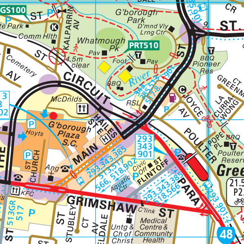
The maps are customised versions of the traditional Melway street directory maps, together with specific visual requirements to suit individual business needs. The end result: customised maps in hardcopy or digital format.
Custom Maps can show & highlight:
- School districts, postcodes and other boundaries
- Catchment areas or territory zones
- Delivery zones or sales territories
- A radius around point & buffer areas
Custom Maps key features:
- Complete Melway road hierarchy
- Inclusion of suburb and municipal boundaries
- Inclusion of parks and recreation reserves
- Inclusion of hydro features – rivers, creeks and wetlands
- Inclusion of schools, sports facilities, hospitals and airports
- Suburb names, postcodes, neighbourhood and local area names
Melway has worked with businesses across the advertising, real estate, construction, education, freight, distribution, mining, warehousing and courier sectors. The company has also assisted some of Australia’s local government departments, including the City of Sydney, the City of Melbourne and the Department of Transport. Past drafting projects have included real estate handout maps, school catchment area maps, transport delivery and territory zone maps and local area guides and brochures.
Like Melway’s traditional street directory offering, the customised maps are the most up-to-date and accurate on the market, and are available in PDF format for use in digital or printed format.
Melway’s years of experience has seen the company develop a variety of mapping options:
- digital maps
- customised maps
- CAD maps
- GIS data
- as well as providing contract drafting services
Contract drafting services is proving popular among trade sectors, including the construction and mining industries. Digital mapping allows for easy-to-use navigation digital maps for vehicles, trucks and smartphones. In keeping with modern technology updates, Melway has created a number of digital products, including the eWay mapping solution, and the iMelway app for iPhone 5, iOS 6 And iOS 5, and can work with businesses to produce various digital products.
BROAD PRICING FOR SOME OF OUR STANDARD CUSTOM MAPS:
200DPI Medium Resolution image for printing/Reproduction:
These images are custom cropped to suit your required immediate area of coverage based on a description supplied by you.
The images have uses for websites, planning, in documents and promotional material. $165 incl gst. Maximum size of 2000px x 2000px x 200dpi at printed Melway street directory scale.
High Res Scaleable PDF for enlarged Printing
Based on our keymaps mapping style and showing main and collector roads only. A customised vector PDF is custom cropped to suit your required immediate area of coverage, based on a description supplied by you. These print ready PDFs can be enlarged without loss of quality. $880 incl gst, plus any additional cartographic manipulation required.
High Res PDF customised area map for enlarged printing or viewing:
Using our highly detailed Melway map base, showing all roads with names and all the features in our detailed map data. A created vector PDF is custom cropped to suit your required immediate area of coverage based on a description supplied by you. These high resolution PDFs can be enlarged without loss of quality. Pricing starts at $880 incl gst and is dependant on area of coverage and cartographic manipulation required.
To get in contact with Melway about custom mapping, call 1300 MELWAY or email: custommaps@melway.com or visit the CONTACT US page.


